
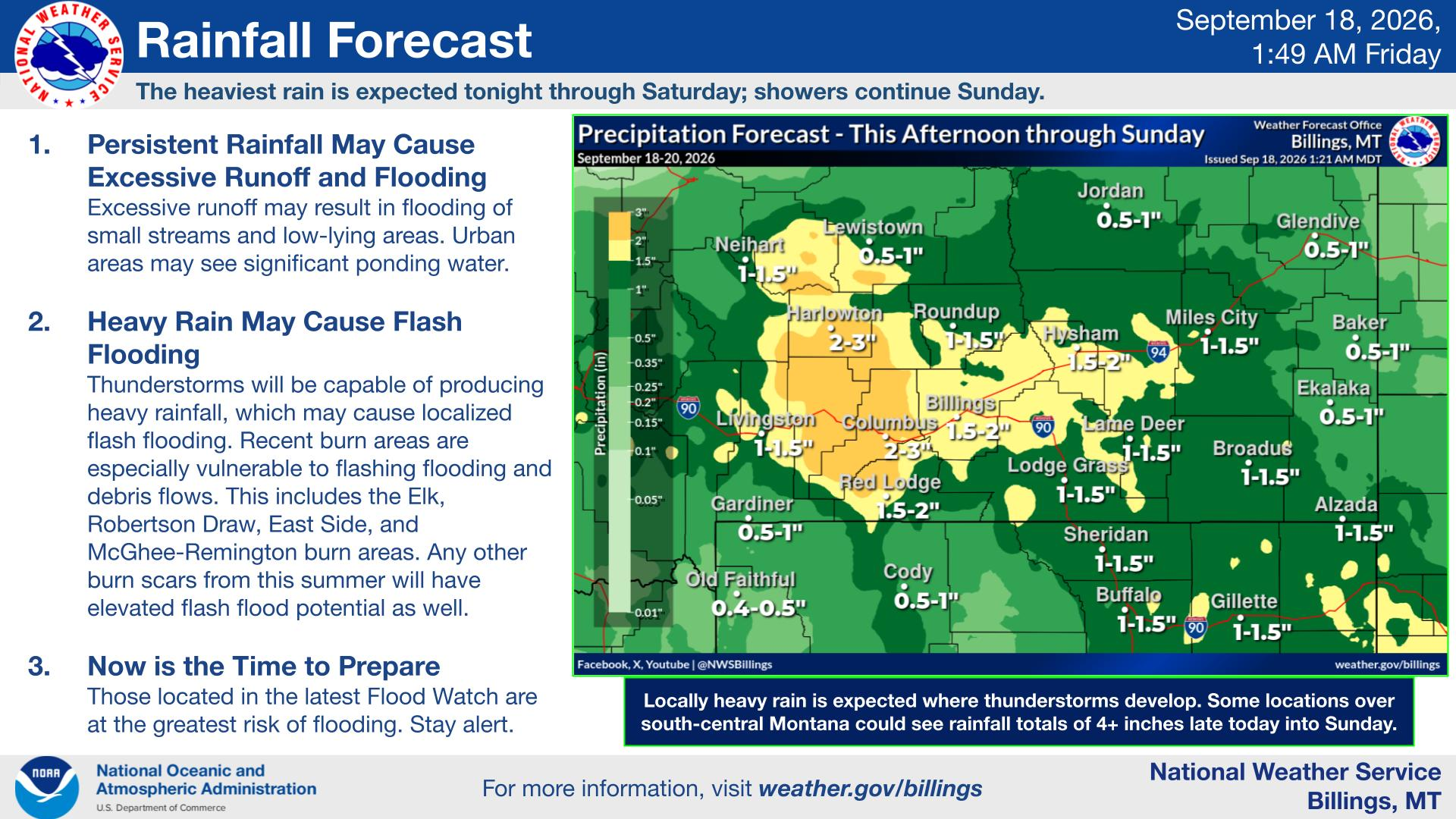
Travelers heading out for mountain camping near Red Lodge and Livingston, Montana, should review the terrain around their accommodations before rain begins. A Flood Watch issued by the National Weather Service (NWS) Billings office at 2:50 a.m. Mountain Daylight Time on September 18 was in effect from 6 p.m. on the 18th through 6 p.m. on the 20th. The watch area was expected to receive 1 to 2.5 inches of rain during that period, with localized amounts up to 4 inches where thunderstorms lingered.
This did not mean every stream was already flooding; rather, it signaled the potential for flooding from heavy rainfall. A slow-moving weather system was expected to bring repeated rounds of rain, so a brief stretch of clear weather at departure was not a reliable indication that conditions would remain the same at a weekend campsite.
Areas Affected
The watch covered all of south-central Montana, portions of southeastern Montana, and Sheridan County, Wyoming. Included were the Red Lodge foothills, Paradise Valley and Livingston, the Absaroka and Beartooth Mountains, and Bighorn Canyon. The Billings office’s September 18 precipitation map projected 1.5 to 2 inches in Red Lodge, 1 to 1.5 inches in Livingston, and 2 to 3 inches in Columbus.
The Robertson Draw, Eastside, Elk, and McGhee-Rimington burn scars were specifically identified as vulnerable to flash flooding and mud and debris flows. It was not enough to watch only whether heavy rain fell directly at the campground. Travelers also needed to check whether slopes and drainage channels above their lodging connected to a burn area.
A Flood Watch should be distinguished from a road-closure order or a campground operating notice. The watch alone did not establish that a specific campground had closed or that Beartooth Highway had been restricted. Travelers needed to separately check their reserved campground’s operating notices and road updates for the day of travel.
What RV Travelers Need to Know
Those with a low-lying site beside a stream should ask the campground about evacuation areas and low sections of the access road. Choosing alternate lodging and a travel route before the watch began Friday evening could reduce the pressure of making those decisions for the first time after dark as water levels rose.
The NWS advised campers in low areas to move to higher ground immediately if water began rising and not to cross flooded roads by vehicle or on foot. An RV’s height or weight should not be treated as evidence that it can make a crossing. Evacuation should not be delayed to retrieve camping gear.
Travelers should have a way to receive information, including mobile alerts and local weather broadcasts, and should continue checking forecast updates from September 18 through 20. For this trip, the key considerations were not a single total-rainfall figure but the campsite’s drainage paths, its relationship to burn scars, and the available route to higher ground.
Photo: NOAA/NWS Billings / Original photo page (Public domain; no copyright is claimed in the original agency work)
Sources: NWS Flood Watch · NWS precipitation forecast · NWS flood safety