
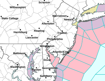
Anyone planning coastal camping near Cape May or Cape Henlopen for the weekend should assess lodging and on-the-water activities separately. A Gale Watch maintained by the NWS Mount Holly office at 3:16 a.m. EDT on October 15 was in effect for the New Jersey coast, Delaware Bay, and the Delaware coast from 6 p.m. on the 16th through 6 p.m. EDT on the 17th. Coastal waters were forecast to see northwesterly winds of about 23 to 35 mph and waves of 3 to 6 feet.
Areas Affected
On the New Jersey side, the watch covered coastal waters from Sandy Hook through Manasquan Inlet, Little Egg Inlet, and Great Egg Inlet to Cape May. On the Delaware side, it included the waters from Cape May to Cape Henlopen and from Cape Henlopen to Fenwick Island. This watch concerned marine conditions and did not mean the same wind speeds or wave heights would apply across all land-based campgrounds.
A Gale Watch also remained in effect for Delaware Bay during the same period. The NWS said northwesterly winds of about 23 to 35 mph and very rough waters were possible within the bay. Gusts near 40 mph were also possible in parts of Delaware’s coastal waters. These were forecast marine hazards, not observed weekend conditions, and travelers should continue checking whether the watch was upgraded to a warning.
The land forecast also showed a sharp shift. The Lewes forecast, updated at 4:09 a.m. EDT on the 15th, called for a high of 82°F on the 16th, followed by rain at night, then a high of 57°F on the 17th with north winds around 25 mph and gusts as high as 35 mph. That is why relatively warm weather Friday afternoon alone was not a reliable guide to conditions for Saturday beach activities.
What RV Travelers Need to Know
The NWS warned that gale-force winds can capsize or damage vessels and reduce visibility, and advised boaters to consider changing plans or remaining in port or another safe harbor. If an RV camping reservation included kayaking, a small boat, or offshore fishing, plans to go on the water should be reconsidered independently of the overnight stay.
When staying near beaches such as Cape Henlopen, check campground and state park operating notices separately, and review the wind forecast for the specific location when traveling on land roads. This marine watch alone did not establish that campgrounds were closed or coastal roads were restricted. Items to check before departure were reservation status, same-day park notices, the land forecast, and the marine forecast.
With rain Friday night and cooler weekend temperatures in the forecast, adjust plans for outdoor meals and time at the beach, and secure items that could blow away. Waves and winds vary by location and time, so figures for one area should not be applied to the entire coast. Checking the latest NWS statement before the evening of the 16th for the watch or warning’s timing and coverage was central to weekend planning.
More information: NWS Mount Holly weather alert map · NWS Gale Watch · NWS Lewes land forecast
Photo: NOAA/NWS Philadelphia/Mount Holly / Original photo page (NWS public information)