
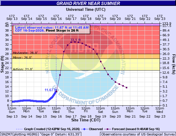
Travelers camping or driving near Missouri’s Grand River should prepare for rising river levels beginning the night of September 16. A forecast issued by NWS Kansas City at 9:51 a.m. Central Daylight Time (CDT) that day projected moderate flooding near Sumner.
Areas Affected
The flood warning for the Sumner reach was in effect from the evening of the 16th through Sunday morning, the 20th. Affected areas included Carroll, Chariton, Livingston, and Linn counties. Segment-specific flood forecasts were also issued for other points along the river, including Pattonsburg, Gallatin, Chillicothe, and Brunswick.
The river level at the Sumner gauge was 10.4 feet at 8:45 a.m. CDT on the 16th. NWS expected it to exceed the 26-foot flood stage late that night and rise to 33.1 feet by the evening of the 17th. Even if the river appeared low during the day, travelers needed to account for the potential for an overnight rise.
According to the gauge’s impact statement, nearby local roads may flood at 28 feet. A gauge reading is not the depth of water over a road, so it should not be compared with an RV’s ground clearance to determine whether it is safe to cross.
What RV Travelers Need to Know
If you had reserved a low-lying riverside campsite, it was advisable to confirm access-road conditions and evacuation guidance with the operator before leaving. Rather than trying to relocate after waters rose, it was safer to identify a daylight exit route and alternative lodging on higher ground in advance.
NWS emphasized that travelers should not drive through flooded roads or go around barricades. Even a large RV or a tow vehicle with high ground clearance cannot reveal washouts or currents beneath the water.
The 33.1-foot figure was a forecast at the time of issuance, not a confirmed crest. This warning alone could not determine whether a particular campground was closed, so river forecasts should be checked alongside notices from on-site operators. Any evacuation order should take priority over reservation plans.
Source: NWS Grand River Flood Warning · NWS Flood Safety Guidance
Photo: NOAA/NWS · Grand River at Sumner gauge observed and forecast river-level graph (data from September 16, 2026).